

 |  |
UPDATE 14SEP22 - 22/P/2108/NMA " Non material amendment to application 19/P/0835/OUT (outline application with details of access (matters of layout, scale, appearance and landscaping are reserved) for the demolition of all industrial buildings, plant and machinery, the erection of up to 42 dwellings and 500 sqm of flexible Use Class A2/B1/D1 floor space, open space, landscaping, new vehicle and pedestrian access, and associated works) to allow the removal of Condition 4 (plans) and the amendment to the wording of Condition 19 (footpaths) | Bleadon Quarry Bridge Road Bleadon BS24 0AU" - No response from BPC as Statutory Consultee?- Despite resident concerns, statements & discussions with Full Council Oct Min 356.3 or Planning Update 356.6 or Dec22 Min 367.6 or Planning Page see below
- Deletion of Condition 4 - relating to agreed plans
- Amend Condition 19 - Mulberry Lane Footpath and removal of hillside footpath
- See Agent Letter, Redacted Application Form and Site Plan.
UPDATE 31AUG22 - 22/P/2113/RM -" Reserved matters application for appearance, landscaping, layout and scale for the erection of 42no. dwellings and office building pursuant to outline permission 19/P/0835/OUT (outline application with details of access (matters of layout, scale, appearance and landscaping are reserved) for the demolition of all industrial buildings, plant and machinery, the erection of up to 42 dwellings and 500 sqm of flexible Use Class A2/B1/D1 floor space, open space, landscaping, new vehicle and pedestrian access, and associated works)" - No response from BPC as Statutory Consultee? - Despite resident concerns, statements & discussions with Full Council Oct Min 356.3 or Planning Update 356.6 or Dec22 Min 367.6 or Planning Page see below
UPDATE 08AUG22 - Application to "Discharge of condition No. 43 (programme of archaeological works)" Application number 22/P/1923/AOC. Documents submitted include Cover Letter, Application and Written Scheme of Investigation for an Archaeological Watching Brief, See also UPDATE 24MAR21 below for previous Archaeological Information - No response from BPC as Statutory Consultee?
- Despite resident concerns, statements & discussions with Full Council Oct Min 356.3 or Planning Update 356.6 or Dec22 Min 367.6 or Planning Page see below
"The Chairman suspended Standing Orders to allow public participation in respect to the following item: 22/P/2113/RM Resolved that the Parish Council’s response would include residents’ concerns regarding potential light pollution and the likely dangers that would ensue with having the footpath from the Quarry into Mulberry Lane opened."??
DEC22 Min 367.6 " The Council agreed not to support" yet not submitted to NSC?
APPROVED 23JAN23 - Decision Notice
UPDATE 16JUL22 - Bleadon Quarry Bought
UPDATE 24MAR21 - Historic letter sent to BOB stating, "There are likely to be some safety concerns regarding any new buildings or construction, both structural and possible pollution of the water course." See also previous NSC Archaeological Report in 2014 re: caves; and Marshalls Archaeological Report.(The same 2011 report seems to have been used for both 2014 & 2019 applications).
UPDATE 01MAR21 - NSC GRANTED OUTLINE PLANNING PERMISSION subject to conditions, see Decision Notice and Delegated Officer Report.
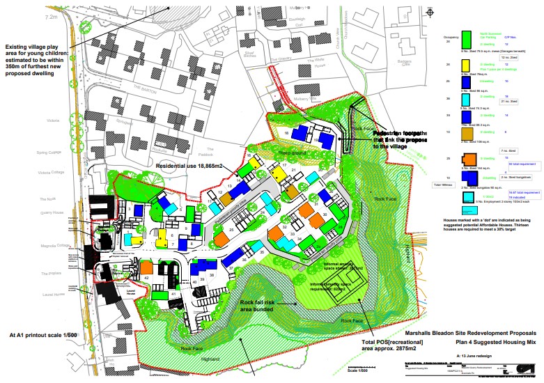
"9 Not more than 30 dwellings shall be occupied before a play area consisting of a minimum of 600m2 together with details of a minimum of six items of play equipment has been constructed in accordance with details that have first been submitted to and approved, in writing, by the Local Planning Authority. Thereafter the play area shall be permanently retained and shall not be used for any purpose other than as a play area. Reason: To ensure that an appropriate play area is provided in accordance with policy CS27 of the North Somerset Core Strategy."
A new outline application at Bleadon Quarry, Bridge Road, Bleadon
"Outline application with details of access (matters of layout, scale, appearance and landscaping are reserved) for the demolition of all industrial buildings, plant and machinery, the erection of up to 42 dwellings and 500 sqm of flexible Use Class A2/B1/D1 floor space, open space, landscaping, new vehicle and pedestrian access, and associated works."
Comments deadline is 01 Aug 2019. Here is the link to the application 19/P/0835/OUT on North Somerset Council Planning website. (Previous information here)
If you prefer to post your comments then the postal address is:
North Somerset CouncilDevelopment Management
Post Point 15
Town Hall
Weston-super-Mare
BS23 1UJ
If you do make comments on this BOB blog (below), please also make sure that they are made to, and appear on, the North Somerset website link as above. As otherwise they will be ignored by NSC.
---
It's surprising to note that this application was validated on last week's North Somerset Weekly List (w/c 01 July 2019) and went to press 08 July but wasn't on the July Agenda and didn't get a mention at Bleadon Parish Council's meeting on 08 July 2019.
- However, it became indirectly noted in the minutes in the 08JUL19 minutes Min 342.7, "19/P/0835/OUT – for information: earlier this year Marshalls advised BPC that they would be renewing their application for homes on their site although they did not have firm plans to cease operation any time soon. The outline application has now been lodged and will be on the next BPC agenda." NB: BPC's next meeting is currently scheduled for 09 Sept 2019.
- It was noted in 20AUG19 Extraordinary Meeting Min 325.11 "19/P/0835/OUT Bleadon Quarry, Bridge Road. Outline application with details of access (matters of layout, scale, appearance and landscaping are reserved) for the demolition of all industrial buildings, plant and machinery, the erection of up to 42 dwellings and 500 2 sqm of flexible Use Class A2/B1/D1 floor space, open space, landscaping, new vehicle and pedestrian access, and associated works"
UPDATE: Some residents have received a letter, dated 05 July 19, asking them for comments on this application by 26 July 2019.
NB: The original outline application Decision Notice, dated 08 Aug 2016 stated, "1. Application for approval of the reserved matters shall be made to the Local Planning Authority before the expiry of three years from the date of this permission." and "2. The development hereby permitted shall be begun either before the expiry of five years from the date of this permission, or before the expiry of two years from the date of approval of the last of the reserved matters to be approved, whichever is the later"
For background on this application and updates please see below.
Previous Quarry 14/P/0687/O at NSC planning website and associated previous BOB Quarry Blog
----
Posted 25 Jan 2021
Proposed Pedestrian Refuge Island - Plan
Posted 17 Aug & 07 Sep 2020 - Highways responses:
"To ensure that access to bus stops is safe and attractive to pedestrians, the developer will be required to provide footway linking Bridge Road to the bus stop on the north east side of the A370 and a pedestrian crossing refuge on the A370 between the stops." 17 Aug 20 NB This is currently a 60mph road!!!
"Addendum (28/07/2020) This addendum has been provided in response to further information and plans from the applicant. Recommendation Subject to the comments and conditions required below, there is now no Highway Authority objection to this application. The applicant has provided the following plan:
Pedestrian crossing, footway and agricultural access plan SK006 P2. Subject to the carrying out of a Stage 2 Road Safety Audit (RSA), and the requirements of that audit being incorporated and approved by our Road Safety Engineer, the proposal for the pedestrian crossing and footway is considered acceptable. Please condition." 07 Sep 20
27 Sept 19 - Highways Second Response
Recommend refusal, RICS data to be updated, 20mph along Bridge Road, S106 TRO yellow lines (£3600), Road Safety Assessment, S278 Trief kerbed speed table, S38 Adopotion of highways and street lighting, footway and refuge to A370 bus stops, potential Mulberry Lane pedestrian and cycle access with associated S106 to upgrade street name plates and signs (£1000), S106 for the purpose of promoting and enabling the use of sustainable methods of transport by residents of the site (£5040)... Consideration of ‘Pedestrian Priority Zones’, S106 for school transport, to support the Joint Local Transport Plan’s goal with upgrades to the existing two stops near Bridge Road (approximately £28,196 plus £800 maintenance per annum not including upgrades/extension to the footway from Bridge Road) ... should benefit from the provision of public transport real-time information, necessary to update the TRICs data as the application contains data from 2014. Use Class A2/B1/D1 (Financial and professional services, Business, Non-residential institutions) under provision of 31 parking spaces with very limited on-street parking available in the vicinity of the site, and additional parking on Bridge Road is likely to make it more hazardous for pedestrians and cause delays for vehicles. Inclusion of Electric Vehicle charging points. Taking into account the local highway network and the volume of material they may need to be removed / brought to site, Highways would request that a construction management plan (Extract)
21 Aug 19 - BPC submitted response to NSC 20 days after deadline re: Min 325.11.
"325.11 To Consider Planning Applications on NSC weekly lists to 19 August. All had been visited by two or more councillors. 19/P/0835/OUT Bleadon Quarry (Marshalls), Bridge Road. This is a re-submission and was supported by BPC last time. It is brownfield, within the settlement boundary, and fits with the Neighbourhood Plan requirements. AGREED TO SUPPORT"
NSC Submission, "At the meeting on 20th August Bleadon Parish Council agreed to support this application again. Councillors had visited the site and discussed the proposed development with the applicant. In particular the council noted that it is a brownfield site, within the settlement boundary, and fits well with the requirements of the emerging Neighbourhood Development Plan to provide some housing for the parish. The provision of some affordable housing and a small amount of employment space is welcomed. Removal of the daily lorry movements is to be welcomed although somewhat offset by the increase in traffic from new housing."
19 Aug 19 - Highways Response -
"... on the grounds of lack of clarity on business use class ... no choice but to offer a recommendation for refusal on the grounds of insufficient parking ... Traffic Generation ... equates to 1 additional vehicle every 2.5 minutes in the morning peak and 1 additional vehicle every 1.5 minutes in the evening peak period ... Access ... to be relocated 15m south of the existing access ... along Bridge Road ... Section 106 agreement for the sum of £3000 for a traffic regulation order (TRO) imposing a 20mph speed limit along Bridge Road and for a TRO for yellow line parking restrictions at the proposed site access ... to provide a Trief kerb for the length of the speed table ... secured through a S278 agreement ... the existing access ... stopped up and its use permanently abandoned" (Extract)
03 July 2019 Marshalls Planning & Affordable Housing Statement
"Affordable Housing - 30% affordable housing provision (i.e. 13 units [marked with a black dot on the plan]) ... with 82% of the units being for social rent and the remaining 18% being for intermediate housing ... The proposal is therefore in accordance with the relevant Development Plan policies." (Extract)
UPDATE 01 AUG 19 Deadline for comments today.
Why only 4 weeks public consultation time? How did this one site, the Quarry, grow from being suitable for 25 dwellings plus mixed use in 2013, to today's NSC Sites Allocations Plan stating 42 dwellings, and this associated application proposal with occupancy for up to 189 people plus five 2-storey buildings for employment use, possibly via a settlement boundary change? Why has BPC decided not to respond by the deadline? (See Proposal Site Map and Policy Background below)
UPDATE 19 JULY 19: Weston Mercury publish "Housing plans for stone quarry put forward again"
UPDATE post-08 JULY 19: Why was this application not on the BPC 08 July agenda (324.7)
... even though it was on the NSC weekly list? Why was this application subsequently noted on the minutes (Min 324.7) even though it wasn't discussed at the meeting at this point? Why and when did BPC decide to put this application for review on their next agenda, currently 09 September, over 5 weeks after the consultation deadline? Why did BPC not ask for an extension for their response as they have for other applications?
"(July 19 Min 324.7)19/P/0835/OUT – for information: earlier this year Marshalls advised BPC that they would be renewing their application for homes on their site although they did not have firm plans to cease operation any time soon. The outline application has now been lodged and will be on the next BPC agenda."
How did this one site, the Quarry, grow from being suitable for 25 dwellings plus mixed use in 2013, to today's NSC Sites Allocation Policy stating 42 dwellings, and this associated application for occupancy of up to 189 people plus five 2-storey buildings for employment use, possibly via a settlement boundary change.
NSC's Replacement Local Plan Written Statement adopted 2007 stated:
"4.7 The primary function of the settlement boundary is to prevent sprawl and concentrate development appropriate to the scale and needs of that community. Settlement boundaries define the limit of development that is necessary to preserve and maintain the character and separate identity of many of the towns and villages in North Somerset, including the protection of important ‘rural gaps’ between settlements.
4.8 The settlement boundaries have been tightly drawn except where there are proposals for development that justify including currently undeveloped land. They were most recently confirmed in the adopted North Somerset Local Plan in June 2000. Given that only limited development is envisaged outside the towns it is considered that there is no justification for a general review of settlement boundaries. Exceptions have been made at ... Bleadon ..., where settlement boundaries have been extended to encompass recent development commitments ..."
NSC's Feb 2013 Site Allocation Plan Consultation Draft
"...Policy DM33: Settlement boundaries... Bleadon: An adjustment to the settlement boundary at Bleadon Quarry ... Policy BL1 Bleadon Quarry, Bleadon ... Policy Intentions: To deliver a positive reuse for the site which reflects local community objectives. To secure an appropriate balance of land uses including residential, employment and community uses on this existing site ...
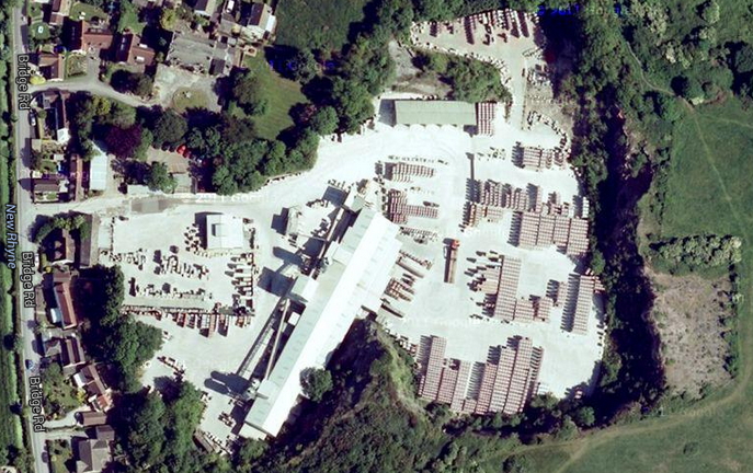
Background: Bleadon is an infill village where Core Strategy Policy CS33 permits small scale residential redevelopment where the proposal is community led with clear community and environmental benefits. Bleadon Quarry is a former limestone quarry located within the settlement boundary, used for the production of concrete products since the late 1980s, but this use is coming to the end of its economic life. It is a brownfield site located within the village, but well enclosed and screened by quarry walls. Bleadon Parish Council supports the mixed use redevelopment of the site where this results in community benefits. The proposed allocation is for 25 dwellings but this figure is subject to further investigation and depends to a large extent on the precise balance of uses eventually proposed on the site, and factors such as the identification of areas of rock fall risk and the extent of shadowing from the quarry walls ...
Policy BL1: Bleadon Quarry, Bleadon. The development of land at the former quarry, Bleadon as shown on the Proposals Map for mixed use will be supported. Proposals must include: l residential development (25 dwellings); l employment use; l community use; l measures to identify the areas of rock fall risk and stabilise the quarry walls; and l protection of living conditions of existing residents and future occupants. Development proposals should meet relevant development management policies, including those relating to biodiversity, in respect of the adjoining Wildlife Site."
"“We [Marshalls] confirm that we have worked closely with Bleadon Parish Council for a number of years now and that we shall continue to do so. “We have always made it clear that the sensitive redevelopment of the Marshalls site shall be our legacy to the village. In this way, we wish to ensure that our future proposals for the site are indeed community-led.”
The [NSC] council’s sites and policies document states that the area could be used for around 20 residential properties, but Marshalls believe this could be more. It is expected a planning application for the quarry could be submitted by the end of this year."
NSC's 2018 Site Allocation Plan
INFILL VILLAGES Bleadon Quarry, Bleadon* 14/P/0687/O Outline planning consent 42 New allocation for a mixed use scheme. 500 sq metres of employment floorspace at entrance of the site. Traffic calming measures on Bridge Road. Pedestrian link along Mulberry Lane. Higher standard of surface water attenuation required.
BLOG EXTENDED UPDATE NOTES:
27 Sept 19 - HIGHWAYS SECOND RESPONSE
- "Recommendation ... refusal until it is demonstrated that the site can be safely accessed and there will not be an unacceptable impact on the local highway network (DM24 Highway Safety of the Sites and Policies Plan Part 1 (2016)) ... RICS data to be updated and uplifted, Road Safety Audit (RSA) to be updated and uplifted, Vehicle Tracking Assessment for the proposed access ... ensure a 20mph speed limit ... along Bridge Road and visibility distances at the site access remain appropriate, the applicant is proposing to provide a speed table at the proposed site access ... Section 106 agreement for the sum of £3600 for a traffic regulation order (TRO) for yellow line parking restrictions at the proposed site access. As a result of the statutory consultation procedures associated with a TRO, its delivery cannot be secured at this time although it is considered unlikely that insurmountable objections will be received.
- Design Manual for Roads and Bridges states that stage 1 and stage 2 RSAs [Road Safety Audit] shall be repeated if the previous RSA for the relevant stage is more than 5 years old. The applicant should therefore commission a new RSA for this application ... provide a Trief kerb for the length of the speed table ... secured through a S278 agreement ... Section 38 Adoption ... includes highways and street lighting which may be offered for adoption as public highways ... The applicant has not provided a vehicle tracking assessment (to include refuse and emergency vehicles) ... Highways seek ... conditions to ensure that the proposed development is served by a safe and adequate means of access.
- To ensure that access to bus stops is safe and attractive to pedestrians, the developer will be required to provide footway linking Bridge Road to the bus stop on the north east side of the A370 and a pedestrian crossing refuge on the A370 between the stops ... The applicant suggests there is 'potential' for pedestrian and cycle access to Mulberry Lane, and pedestrian access to join a public footpath to the north east of the site ... indicating that Mulberry Lane is a no through road ... Highways requires the developer to enter into a S106 agreement for the sum of £5040 (£120 per dwelling) for the purpose of promoting and enabling the use of sustainable methods of transport by residents of the site ... Consideration needs to be given to ‘Pedestrian Priority Zones
- North Somerset Council will seek recompense to mitigate the need for school transport through a Section 106 agreement ... [Section 106 agreement at reserved matters stage] to support the Joint Local Transport Plan’s goal to promote accessibility and the requirement to meet equality and diversity legislation, upgrades to the existing two stops near Bridge Road are required ... For indicative purposes, the bus stop upgrades and shelters will cost approximately £28,196 plus £800 maintenance per annum. This does not include upgrades/extension to the footway from Bridge Road ... Highways would recommend that a development of this size should benefit from the provision of public transport real-time information ... it is necessary to update the TRICs data as the application contains data from 2014.
- proposed 500 sqm of flexible Use Class A2/B1/D1 ... under provision of 31 parking spaces ... very limited on-street parking available in the vicinity of the site, and additional parking on Bridge Road is likely to make it more hazardous for pedestrians and cause delays for vehicles ... Highways would welcome the inclusion of Electric Vehicle charging points
- Taking into account the local highway network and the volume of material they may need to be removed / brought to site, Highways would request that a construction management plan is submitted to the LPA for approval prior to the commencement of development on site. This should include but not be limited to, HGV routing, provision for staff car parking, times of site operation, volume of HGV movements throughout the day, highway safety measures such as wheel washing facilities and mitigation measures for any remedial works required. Please condition."
19 Aug 19 - HIGHWAYS RESPONSE
- "Recommendation ... Highways are unable to offer a favourable recommendation on the grounds of lack of clarity on business use class. In the absence of this, Highways would have no choice but to offer a recommendation for refusal on the grounds of insufficient parking
- Traffic Generation ... Compared to the existing peak hour traffic generation of the site recorded by surveys undertaken in January 2014, this results in an additional 24 morning peak hour movements (15 arrivals and 9 departures) and an additional 41 evening peak hour movements (18 arrivals and 23 departures). This equates to 1 additional vehicle every 2.5 minutes in the morning peak and 1 additional vehicle every 1.5 minutes in the evening peak period.
- Access ... The vehicular access to the proposed development is to be relocated 15m south of the existing access via a simple priority access with Bridge Road comprising a raised table with vehicle restraint measures ... In order to ensure a 20mph speed limit can be achieved along Bridge Road and visibility distances at the site access remain appropriate, the applicant is proposing to provide a speed table at the proposed site access ... Whilst this level of additional traffic is not considered significant or severe in traffic volume terms, the nature of Bridge Road as a village access road which operates informally as shared space, means that the additional traffic movements may be perceptible to residents and other road users. Notwithstanding this, traffic route assignment and junction capacity assessments outlined below indicate that the highway should continue to operate satisfactorily ... Highways requires the developer to enter into a Section 106 agreement for the sum of £3000 for a traffic regulation order (TRO) imposing a 20mph speed limit along Bridge Road and for a TRO for yellow line parking restrictions at the proposed site access. .... A Stage 1 Road Safety Audit (RSA) of the proposed access has been undertaken and highlights a concern relating to vehicles emerging from the proposed access potentially entering the adjacent ditch as a result of the raising of the carriageway to create a speed table. It makes the recommendation that a vehicle restraint system should be implemented in this area to reduce the potential risk of vehicles entering the ditch associated with the increase in user numbers associated with the development. The designer’s response rejects this recommendation, but in the interest of providing a safe access Highways requires the developer to provide a Trief kerb for the length of the speed table. If the planning authority is minded to approve the application, this will be secured through a S278 agreement ... The development shall not commence until the existing access has been stopped up and its use permanently abandoned concurrently with the provision of the new access, in a manner to be agreed in writing by the Local Planning Authority."
03 July 2019- MARSHALLS PLANNING & AFFORDABLE HOUSING STATEMENT
"Affordable Housing
- 6.6 As with the extant planning permission at the site, this scheme proposes a policy compliant 30% affordable housing provision (i.e. 13 units [marked with a black dot on the plan]). It is currently anticipated that the tenure split will be in accordance with Policy CS16, with 82% of the units being for social rent and the remaining 18% being for intermediate housing. This is, however, subject to discussion with the Council during the planning application process and current local need.
- 6.7 In terms of layout and design, the indicative scheme illustrates how the 13 affordable housing units can be integrated and distributed throughout the development, consisting of no more than six affordable housing units in one location.
- 6.8 Overall, the scheme provides the required 30% provision and illustrates how such units can be suitably accommodated at the site. The proposal is therefore in accordance with the relevant Development Plan policies, namely Core Strategy Policy CS16, as well as other material considerations including the Affordable Housing SPD and NPPF."
- "29 Not more than 30 dwellings shall be occupied before the play area totaling a minimum of 800m2 has been constructed in accordance with details that have first been submitted to and approved, in writing, by the Local Planning Authority. Thereafter the play area shall be permanently retained and shall not be used for any purpose other than as a play area."
Make A Comment
Comments (0)