Also like us on...
and Twitter Follow @BleadonTweet


GEOGRAPHIC MAPPING
|
|
|
|
|
|
|
|
|
 |
|
|
NSC Planning Apps |
|
ArcGIS World Maps |
|
|
 |
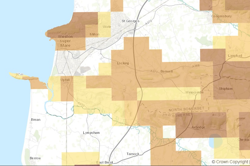

Bristol Water currently supplies the water in the North Somerset, Somerset and Bristol counties. Its Southern Resilience Scheme (p35) was a new £27 million water infrastructure project, which "will help us meet the increase in demand for water over the coming years. Weston-Super-Mare is one of Europe’s fastest growing towns, and so we need to supply all of the new residents and businesses coming to the area". This map shows the extent of the project. To find if this is happening in your area enter your postcode and zoom out to see the associated information more clearly. You can also compare the extent of the fracking licences in the North Somerset area to local reservoirs here."
"The MAGIC website provides geographic information about the natural environment from across government. The information covers rural, urban, coastal and marine environments across Great Britain. It is presented in an interactive map which can be explored using various mapping tools that are included. Users do not require specialist software and can access maps using a standard web browser."
"Find data published by government departments and agencies, public bodies and local authorities. You can use this data to learn more about how government works, carry out research or build applications and services"
Environment Agency works "to create better places for people and wildlife, and support sustainable development. Within England we’re responsible for: regulating major industry and waste, treatment of contaminated land, water quality and resources, fisheries, inland river, estuary and harbour navigations, conservation and ecology...." It offers environmental data and maps on a number of topics. You can choose a topic, enter your postcode and click on the map to read the associated information e.g. aquifers, water abstraction from ground and surface water sources, drinking water safeguard zones, flood mapping, pollution and other topic areas, just choose the drop down menu to change options.
"An online resource that enables visitors to easily and quickly use maps in order to measure, search and overlay mark-up elements on maps for a wide range of useful applications"
"This interactive map has been produce by OGA to assist companies and members of the public with informatin that will help understand oil and gas exploration and production in the UK's Territorial Sea and its designated Continental Shelf ("the ffshore are"). This includes those areas alreaddy under licence and those areas that are on offer in OGA's licensing Rounds.
Licenses that are awarded by OGA may contain conditions to protect environmental interests, and the interests of other sea users. In addition, activities carried out under the licences will be subject to a range of legislation which is designated to protect the marine environment, including regulations which apply the Environmental Impact Assessment and Habitats Directives to offshore oil and gas activities.
The Offshore Petroleum Regulator for Environment and Decommissioning (OPRED) is the unit within BEIS responsible for ensuring that the economic exploitation of offshore energy resources takes full account of environmental and social objecties."
Mapping of data relating to NSC Planning decisions and policies.
Mapping of NSC services, e.g. Benefit Surgeries, Community Venues, Council Car Parks, Leisure Centres, Libraries, Public Toilets, Pupil Referral Unit & Tuition, Recycling Box Net Retailers, Recycling Facilities, Schools.
Mapping of NSC Sites of Housing & Land Availability Assessment (SHLAA)
See also (Jan19) replaced with Housing and Economic Land Availability Assessment HELAA 2014) see NSC SHLAA report (Sept 18) for further information inlcuding Appendix A and Appendix B
"Flightradar24 is a global flight tracking service that provides you with real-time information about thousands of aircraft around the world. Flightradar24 tracks 180,000+ flights, from 1,200+ airlines, flying to or from 4,000+ airports around the world in real time. Our service is currently available online and for your iOS or Android device."
UKRadon is the UK reference site on radon from Public Health England (PHE). As the UK's primary experts on radiation protection, PHE "represents a significant nationwide resource for the public, industry, education, research and medicine and is the primary resource for advice about radon in the UK. Radon is a natural radioactive gas, you can't see smell or taste it. In outside air the levels are low but it can accumulate inside buildings. Certain areas of the country are more prone than others." To check whether you are in a potential radon area enter your postcode at the UKRadon website, click show radon data and then click on the map to read the associated information.
"The European-Mediterranean Seismological Centre (EMSC) was founded in 1975, following a recommendation from the European Seismological Commission (ESC). The ESC is a regional commission of the International Association of Seismology and Physics of the Earth's Interior (IASPEI), itself a specialized association of the International Union of Geodesy and Geophysics (IUGG).
The recommendation was based on the consideration that the European-Mediterranean region displayed a potentially dangerous seismic activity. Consequently, for reasons of protection of society and evaluation of earthquake danger, it was necessary that a scientific body undertook the very rapid (close to real- time) determination of these destructive earthquakes. The rapid determination of the location of earthquakes of lesser magnitude was also considered. This recommendation subsequently gained the support of IASPEI and IUGG.
The centre started its operations at the Institut de Physique du Globe de Strasbourg (IPGS) on 1 January 1976 and formally received it statutes in 1983. The EMSC is an international, non-governmental, and non-profit association. The activity of the EMSC members is devoted to the promotion of seismological research. In this framework, EMSC runs an Earthquake Alert System for potentially damaging earthquakes in the Euro-Med region which consists of the rapid determination of the epicentre and the dissemination of the seismic alert message within the hour following the occurrence of the earthquake
The EMSC undertook a major evolution in 1993. The statutes were modified consecutively to an Extraordinary Assembly, held in Rome on 13 December 1993. The EMSC seat was moved to the Laboratoire de Détection et de Géophysique (LDG) of the Commissariat à l'Energie Atomique (CEA) in Bruyères-le-Châtel (Essonne, France).
In 1987, the EMSC was charged by the Council of Europe (CoE) to provide the latter with seismic warnings in the framework of the Open Partial Agreement (OPA) on the prevention of, protection against, and organisation of relief in major natural and technological disasters."
See video overview
___