Also like us on...
and Twitter Follow @BleadonTweet

Development in the Bleadon Parish Area
& Related Policies
The following maps were created, and subsequently annotated, using the NSC GIS system which is a useful resource to see what policies and emerging proposals affect our land and environment in North Somerset. Also see the associated Major Development Table containing site specific information and questions to Bleadon Parish Council and North Somerset.
Map 1 annotation indicates 'major' planning applications of recent years and the critical road junctions affected. It indicates how our rural area is threatened with environmental attack through traffic and light pollution; and why essential health services such as hospital/GP, dental appointments are so difficult to get. Apparently there is a central government formula that gives extra health service funding based on population; from our perspective this clearly isn't working as they are stretched already yet more houses and people are planned! See table of Major Development Applications in and around Bleadon and the related Weston General Hospital Services Reduced Blog.

Map 2 is an image of Bleadon Parish Boundary showing the Settlement Boundary. Note 2011 Census recorded 530 dwellings in Bleadon, so clearly these additional development applications will make a significant difference to our environment, health and wellbeing when built.

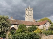
Map 3 is an image of Bleadon Settlement Boundary.
North Somerset's Core Strategy section CS14 (p67-70) states "Settlement boundaries define the area within which residential development is acceptable in principle, subject to compliance with other policies in the plan. Development outside the settlement boundaries will only be acceptable where a site is allocated in a Local Plan or where it comprises sustainable development which accords with the criteria set out in the relevant settlement policies (CS28, CS31, CS32 and CS33)."
Bleadon appears in NSC Core Strategy section CS33 (p133/4) as a designated 'infill' village and below shows the Settlement Boundary beyond which any development is supposedly more tightly controlled on criteria specified by the National Policy Framework (NPPF) and NSC Core Strategy policies. Bleadon's 20 year Parish Plan was formulated in 2005, adopted in 2009 and sent to NSC to feed into the NSC Replacement Local Plan process. (Folllowing the Localism Act 2011 it is now known as the 'Core Strategy'). Unfortunately despite costing thousands of pounds it can't be found by either BPC or NSC, although BOB still has a draft 2008 copy along with the Questionnaire data and background information here. The Localism 2011 Act introduced Neighbourhood Plans and now (if produced) they specify where local housing and economic development is desired. However, BOB and others (see CPRE) still believe that our Parish Plan data and 103 Actions should still play an essential, valuable and central role in routinely steering the holistic direction of BPC resource allocation in performing their duties/powers and decision making, including what applications to 'grant' or 'refuse'.
The Inspector's Note to NSC concluded (in para 27), among other things, that she will "therefore look to the Council to test the allocation of additional sites within the SAP which would have the capacity to accommodate up to 2,500 dwellings, and which have a realistic chance of being delivered by the end of the CS period in 2026." Following which more sites will presumably be requested for potential development.
It should be noted that it was also stated (in para 24): "The following sources are identified by the Council for the additional allocations which are to be tested: Sites which are broadly consistent with the Core Strategy spatial strategy (sites within or adjacent to Weston, the towns and service villages, but not infill villages, countryside or Green Belt)."
See Settlement Boundary Information update July 2017.
Also see the extracts from the Bleadon Action Plan and email queries sent to BPC during the Bleadon Hill Public Inquiry Dec 2016.

Map 4 North Somerset Green Belt. It seems that Bleadon Parish is not in a North Somerset Green Belt area, whereas villages to the North East are within Bristol & Bath Green Belt. Perhaps this is why there is so much pressure on Weston-super-Mare and the surrounding villages to build, with WSM stated as being "one of Europe's fastest growing towns". See North Somerset's Core Strategy section CS6 (p43/4) for more information. Also listen to MP Liam Fox's explanation of how we got to this position.

For some background as to why developers continue to pressure NSC Planning please see related documents below. How do all these policies fit together, if at all? Is government joined up?
National Documents
National Planning Policy Framework 2012 (NPPF) - "The National Planning Policy Framework was published on 27 March 2012 and sets out the government’s planning policies for England and how these are expected to be applied."
New Homes Bonus - "The New Homes Bonus is a grant paid by central government to local councils to reflect and incentivise housing growth in their areas. It is based on the amount of extra Council Tax revenue raised for new-build homes, conversions and long-term empty homes brought back into use. There is also an extra payment for providing affordable homes." The associated spreadsheet indicates 'Total payment in year (inc previous delivery)' is £5 million?
Regional Documents
West of England Joint Spatial Plan Initiative "The four West of England authorities are working together to prepare a Joint Spatial Plan (JSP) and Joint Transport Study. The West of England’s Joint Spatial Plan will set out a prospectus for sustainable growth that will help the area meet its housing and transport needs for the next 20 years". See map of areas covered.
District - North Somerset Documents
Core Strategy/Local Plan - "The Core Strategy sets out the broad long-term vision, objectives and strategic planning policies for North Somerset up to 2026. It is more than just a land use plan; its scope is wider, focusing on place shaping and the creation of sustainable communities, and demonstrating links to related issues such as health, education and wellbeing. This approach is summarised in the term ‘spatial planning’."
NSC Sites and Policies Development Plan (SAP) is related to the Core Strategy with the Sites and Policies Plan Part 2: Site Allocations Plan examination being recently undertaken. The Site Allocations Plan was submitted to the planning inspectorate for examination on 24 February 2017 who received statements regarding Bleadon. E.g. Sanders' Hearing and Supplementary Hearing statements question the designation of the fields adjacent to Bridge Road and potential use as a school. Sanders made a submission "in relation to land at Bleadon due to their proposed designation under the Site Allocations Plan as proposed “Strategic Open Space” and the failure of the LPA to consider a proposed mixed residential and community use at the Site"
What is the current situation? How does this fit with the Settlement Boundary? If a school and other services are built this may affect Bleadon's Infill status making it a Service Village, potentially increasing the risk of even more housing development in the area. Also it's not clear who made the SAP response regarding a school (indicated in Sanders' Hearing statement) as the Bleadon Parish Plan data (click on Q78) shows only 26% of people indicated that they wanted a village school? Also, the results of Sanders May 2011 Public Consultation (which did not mention a school) indicated that 80% of respondents said 'NO' to development on these fields and it was stated that "Chris and Mike will pursue it no further" (See BVN89 News & Views). Were BPC asked to comment on SAP Plan? If, so did they respond? What did they comment on behalf of Bleadon residents?
Inspector's Report (26 Jun 17) The Planning Inspector has recommended that the supply of deliverable and developable land identified to secure the delivery of a minimum of 20,985 dwellings within North Somerset 2006–2026, be increased to accommodate an additional 2,500 dwellings. Who says we need all this housing and why? What is the penalty if they are not built? In July 17 District Cllr Ap-Rees spoke about this matter in the Western Daily Press..
On 2 Nov 16 The Campaign to Protect Rural England (CPRE) posted "More than a million homes possible on suitable brownfield land"
On 15 Dec 14 local MP Liam Fox spoke out in parliament (skip to 21:58 mins) on behalf of North Somerset and the high extra housing development imposed by central government coming from the Bristol University court challenge wanting to build on Green Belt land. NSC was subsequently asked to increase indentified sites from 14,000 to 21,000 houses. Liam Fox MP said, ".. it must be made clear that greenfield development should come only as a last resort after all brownfield sites are exhausted (See letter from DCLG relating to the Dec 2017 Brownfield Register). Finally, the infrastructure that is needed to support new development, including schools, GP surgeries and, where appropriate, roads must be provided by the developers; the cost must not fall disproportionately on local council tax payers. (See related Blog on Weston General Hospital A&E night-time closures starting 4 Jul 17). In North Somerset we are facing an expensive fiasco that is undemocratic and producing unsustainable outcomes. We have been very patient, and our very competent council has been extremely co-operative. Now we need answers."
Liam Fox MP also said, "We seem to be in a ridiculous position. The plan [NS Core Strategy] was put forward in 2011, agreed by the inspector and adopted in 2012, yet here we are at the end of 2014. If I am not mistaken, at the end of 2015, we will begin the planning period in which we will look at housing allocation through to 2036. It would be the height of absurdity if we were one of only four councils in the sub-region to be asked not only to look at our 2026 housing allocation, but to start the process all over again at the end of next year and look at the 2036 allocation. Surely this is a complete waste of public resources, as well as being utterly contrary to what my hon. Friend the Minister says is the Government’s aim, which is to encourage greater localism." (current allocation of 20,985 is only up until 2026 so NSC will be looking for more sites). The Minister of State, DCLG representative Brandon Lewis replied "My right hon. Friend is absolutely right that we want to encourage localism. That is why we want the decisions to be made locally ... I am happy to discuss this issue with my right hon. and hon. Friends in greater detail at an appropriate point and to write to them to outline the detail behind their queries" (Link to Hansard Transcript and further information.)
On 23 Jan 17 we asked North Somerset's local MP John Penrose MP his views, in which he referred to working with others to protect its villages and countryside; and the importance of "A democratically-agreed Local Plan". Note: In 2009 BPC publicly declared that it had submitted Bleadon's adopted Parish Plan to NSC for inclusion/reference in any NSC plans or policies; and to ensure that Bleadon residents' views were known and acted upon (it appears NSC did not receive the plan in 2009 and it is now 'lost'?). Following BOB's query regarding the status of the NLUD ("a countrywide source of information on brownfield land") John Penrose passed on a response to us from DCLG, stating "With effect from 16 Apr 17, each local authority is required by law to create an easy-to-access Brownfield Register and publish it on its website by 31 Dec (17). However, only sites suitable for new homes are to be included." Also, "With effect from 15 Apr (17) the Town and Country Planning (Permission in Principle) Order 2017 enables local authorities to grant Permission in principle to housing-led development on suitable land entered on a brownfield Register".
Parish - Bleadon Parish Documents
2009 adopted Parish Plan (Min 213.27.12, currently 'lost' by BPC). BOB only has Draft 2008 Parish Plan "This is our draft plan for making Bleadon an excellent place to live and work. This draft Parish Plan is about how the parish council, together with residents proposes to develop a safe, sustainable and attractive community. It sets out what has been done since the Parish Plan process was starled and what remains to be done. The parish council cannot work alone in making it right for residents in Bleadon. lt requires action in partnership with North Somerset Council, Somerset County Council, Sedgemoor District Council, the Police, NHS, other agencies and residents."
103 Improvements Leaflet sent to all residents in 2009. "This summary of key points from the Bleadon Action Plan 2009 shows some of what still remains to be done. The parish council alone cannot make these things happen. We will work with you, North Somerset Council and other authorities to make things right for people in Bleadon. Pleasing all of the people all of the time is an impossible task, and we cannot deliver everything that people want. lf you have something to say about these plans please let us know" ... Where are these plans, including the Parish Plan? Why is BPC not using them for the benefit of our community? Why is BOB called vexatious for asking for them and for BPC to declare its vision for the future of Bleadon?
Additional information on the Parish Plan and associated documentation can be found on BOB here.