
| 
|
|
What are these bridleway plans, how are they funded and when were residents consulted? Why is there no clear information on the Parish Council website or minutes?
How was this particular PROW, out of Bleadon's 20 PROWs chosen as the one to focus on and upgrade? When did this project get announced at full council or is the one line statement below the whole project statement, consultation, funding and decision making process? Will BPC have any ongoing maintenance costs or liabilities?
At the last Bleadon Parish Council meeting in July, there was an agenda item to discuss some obscurely identified footpaths, but BPC do not publish associated appendices with the agenda to residents, so it's not clear what this project was all about:
Min 355.7.2 "To resolve to receive a report submitted by Cllrs. S Garrett and G Getty with respect to Footpaths AX6/01/10 – AX6/10 – AX6/12 – AX6/18 – AX6/21 – AX6/10 (attached)".
Prior to the meeting, BOB emailled BPC asking for clarification on these footpaths (and the financial reserves), but later received the response, "I think you will now be aware from last evening’s meeting as to what the answers are to your two questions". No appendices, reports or further information were made publicly available, or sent to BOB, yet somehow a related image (presumably confidential to BPC?) was posted on a closed social media site, as seen above?
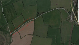
As the minutes of the July meeting will not be published by BPC until the next council meeting in September, the details of this project will remain unclear for at least another month. From BOB meeting notes, this project seems to involve funding/grant (£15K?) from Hinkley Point C, someone approached BPC regarding six footpaths (only five listed?), with BPC deciding/agreeing to develop one part (?) of the 3km bridleway across the Bleadon Levels (full length indicated in green on the map). The lead councillor in attendance indicated an urgent need for BPC(?) to accept this funding/grant now/July, although no deadline was given?
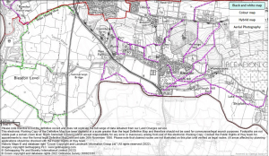
From BOB's PROW page, and in reference to NSC PROW mapping (NB tick Public Rights of Way on the left hand side of the screen):
- AX6/01/10 - Toll Road to Wallborough Reserve, across Bleadon Levels
- AX6/10 - Roman Road to Croquet Club, via The Dring,
- AX6/12 - Purn Way to Shiplate, via Pear Tree Gardens, Churchyard & Lake Farm
- AX6/18 - Mearcombe Lane to Christon Plantation, via Shiplett Farm
- AX6/21 - Hellenge to Roman Road, via AWT Hellenge Hill
- AX6/10 - repeat of above?
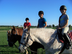
From BOB meeting notes, only the proposed Toll Road Bleadon Levels bridleway was discussed, but none of the other five(?) options? BPC's project lead councillors were proposing stoning the full width of part of the Toll Road bridleway path, mainly for use by walkers and cyclists. However, it was stated by other councillors at the meeting that as this is a designated bridleway, this suggestion wouldn't be good for horses who currently use the grass path between two stoned lanes (similar to image here)? Why isn't the information relating to this large-scale project published to residents in the appendices, working group notes or on the BPC website? Does the related image above accurately represent the bridleway under BPC discussion, if so when was it released to the public by BPC?
A verbal presentation regarding the bridleway was given by Phillip Hackett from the British Horse Society before the start of the council meeting. A summary of the presentation as handed to BOB at the meeting can be found here. Councllors later discussed that members of the public, and horses, should not stray outside the permitted width of the bridleway/PROW or use the verges, as it is not the official path. Therefore, the surface of this bridleway must cater for horses, not just walkers and cyclists. (NB BHS Bridleway Dimensions)
It is important to protect the different types of highway/bridleway/footpaths otherwise residents and members of the public may not be able to continue to use them as they do now. For example the Highway Code Rules About Animals states
Rule 54 "You must not take a horse onto a footpath or pavement and you should not take a horse onto a cycle track" (PDF also BHS)
The use of these PROWs as a bridleway should therefore be protected.
Public Rights of Way (PROW) are North Somerset and Landowner responsibilities. It has been asked that if Bleadon Parish Council becomes involved in the decision making and funding of this bridleway/public right of way as indicated above, will it become responsible for its future maintenance and any public liabilities by default? What are the estimated ongoing costs for Bleadon resident taxes/precept, if any?
Contrary to what was stated at the meeting, according to the government website, the Local Highway Authority (North Somerset) have responsibilities including:
"The highway authority must keep the surface of public rights of way which are maintained at public expense in a fit state for public use", i.e. not Bleadon Parish Council via taxes/precept from its residents (PDF)
Landowners have separate responsibilities (PDF)
-----
See also:
- BPC Rublic Right of Way Minutes and Notes upto Apr2020
- What information do councils need to publish? and Template Comparison
- North Somerset Council Rights of Way Improvement Plan 2007 – 2017 (revised November 2010)
- Council Claims (PDF)
Make A Comment
Comments (0)