

UPDATE JUNE 2018 - Applicant submits an Appeal to the Planning Inspector
UPDATE 23 OCT 17 - Application Refused by NSC the Delegated Report is also available.
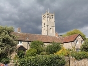
A new application for a the "Erection of a two storey dwelling and a single storey detached garage following the demolition of existing stable building", on another green field site outside of the Settlement Boundary!
Comments deadline is 27 July 2017. Here is the link to the application 17/P/1484/F on North Somerset Council Planning website
If you prefer to post your comments then the postal address is:
North Somerset CouncilDevelopment Management
Post Point 15
Town Hall
Weston-super-Mare
BS23 1UJ
If you do make comments on this BOB blog (below), please also make sure that they are made to, and appear on, the North Somerset website link as above. As otherwise they will be ignored by NSC.
Major Developments in and around Bleadon | Other Information |
|
|


| View Now | Proposed |
 |  |
Despite this application being outside the Settlement Boundary/Village Fence with a Public Right of Way through the middle of the site, following their Parish Council meeting Monday 10 July 17 our five parish council representatives submitted the following comment to NSC as follows:
- "Bleadon Parish Council has no objections to this application"
North Somerset make the decision on this development application. If you want your individual voice heard you need to comment directly to NSC.
- On 2 Nov 16 The Campaign to Protect Rural England (CPRE) posted "More than a million homes possible on suitable brownfield land".
- On 15 Dec 14 local MP Liam Fox spoke out in Parliament on behalf of North Somerset and the high extra housing development imposed by central government coming from the Bristol University court challenge wanting to build on Green Belt land. NSC was subsequently asked to increase indentified sites from 14,000 to 21,000 houses. Liam Fox MP said, ".. it must be made clear that greenfield development should come only as a last resort after all brownfield sites are exhausted".
- On 10 May 2017 DCLG wrote "With effect from 16 April 2017, each local authority is required by law to create an easy-to-access Brownfield Register and publish it on its website by 31 December. However, only sites suitable for new homes are to be included".
- How can any green field site be considered until this exercise has been completed? Any NSC policies that are currently in place to protect green fields and infill villages should be upheld, e.g. Core Strategy, Parish Plans, etc.
- How will the Public Right of Way across this greenfield site be diverted, extinguished or created as requested by the applicant? Bleadon has already lost its circular walk on South Hill when that landowner made changes
- This application is in a Bat Habitation zone,has had nesting birds and is near two separate Sites of Nature Conservation Interest (SNCI). What other creatures will be affected? The applicant's own form indicates that "Although not within the ANOB it is considered that this site is important within the context of Policy DM11"
- We therefore believe that this application should be refused.
Firstly and fundamentally, Bleadon is a NSC (CS33) designated Infill Village and this application site is outside of the long established Settlement Boundary, so surely this application must be rejected as otherwise what is the point of the designation and the Core Strategy Local Plan Policy which involved extensive consultation and costly production. Also the 20 year Bleadon Parish Plan that was previously adopted by BPC in 2009 states it will "Through the Planning process vigorously question all development outside the Village Settlement" and "Ensure that all new development is within the village Settlement Boundary". Also NSC Corporate Plan stating they need to "promote growth without compromising the things that we, and our millions of visitors, love about North Somerset: our beautiful countryside, stunning coast and distinctive towns and villages, each with their own unique character."
ASSOCIATED BOB BLOGS:
90 Static & Touring Caravans at Purn/Riverside Village on greenfield site outside Settlement Boundary.
16 Houses on Land Off Purn Way on greenfield site outside Settlement Boundary.
70 Dwellings at Devil's Bridge Bleadon Hill BOB Blog on greenfield site near Parish Boundary
Make A Comment
Comments (1)
As per DM11 (ANOB), this application will affect views to/from ANOB.
Although this is not a Rural Building conversion, DM45 (The conversion or reuse of rural buildings to residential use) may still be relevant as it is not clear locally that the 'stable' was ever a permitted development and certainly was never fully built so should probably be demolished anyway. If it was permitted, then it's replacement will certainly not be in keeping and enhancing the location (outside settlement boundary), being substantially larger 2 story dwelling and also affecting views from the West Mendip Way PROW and local residents through additional services, lighting (dark skies) etc.
It will also reduce the rural economy by loss of available grazing and/or land for UK Food Security purposes.